 : Bridge 181, Hardings Bridge
 : track bridge
 : https://www.openstreetmap.org/?mlat=51.380989127794&mlon=-2.30667907501317#map=17/51.380989127794/-2.30667907501317
\", taken near Bridge 181, Hardings Bridge by michaelday_bath on Flickr.")

: Bridge 181, Hardings Bridge: track bridge: https://www.openstreetmap.org/?mlat=51.380989127794&mlon=-2.30667907501317#map=17/51.380989127794/-2.30667907501317
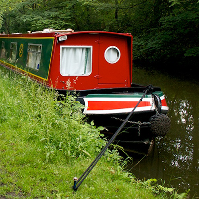
: Bridge 182, Bathampton Swingbridge: track bridge: https://www.openstreetmap.org/?mlat=51.3922181605156&mlon=-2.31409852917742#map=17/51.3922181605156/-2.31409852917742
\", taken near Bridge 182, Bathampton Swingbridge by michaelday_bath on Flickr.")
: Pumping Station (New), Claverton: pumping station: https://www.openstreetmap.org/?mlat=51.3778556739364&mlon=-2.30141382621902#map=17/51.3778556739364/-2.30141382621902
#canal #river #narrowboat #barge #gongoozler #england #uk #flickr #ferry #lane #claverton #bath #north #east #somerset #west #ba2 #7bh #united #kingdom #july #2022 #gb #ferrylane #bathandnortheastsomerset #westofengland #ba27bh #unitedkingdom
, Claverton by sergei.gussev on Flickr.")
A lunchtime walk in #RainbowWood at #Claverton Down on the edge of #Bath. Just wonderful to have brilliant sunshine on this crisp #autumn day. A few leaves still on the trees, and an occasional burst of #birdsong. And, for #Mosstodon, a couple of tree stumps covered in #moss.


 with a few yellow leaves reaching up to the deep blue sky.")