
Carrie BKBurrowing owls<br>
<br>
<a href="https://pixelfed.social/discover/tags/burrowingowls?src=hash" class="u-url hashtag" rel="nofollow noopener" target="_blank">#burrowingowls</a> <a href="https://pixelfed.social/discover/tags/owl?src=hash" class="u-url hashtag" rel="nofollow noopener" target="_blank">#owl</a> <a href="https://pixelfed.social/discover/tags/raptor?src=hash" class="u-url hashtag" rel="nofollow noopener" target="_blank">#raptor</a> <a href="https://pixelfed.social/discover/tags/birdofprey?src=hash" class="u-url hashtag" rel="nofollow noopener" target="_blank">#birdofprey</a> <a href="https://pixelfed.social/discover/tags/naturephotography?src=hash" class="u-url hashtag" rel="nofollow noopener" target="_blank">#naturephotography</a> <a href="https://pixelfed.social/discover/tags/nature?src=hash" class="u-url hashtag" rel="nofollow noopener" target="_blank">#nature</a> <a href="https://pixelfed.social/discover/tags/birds?src=hash" class="u-url hashtag" rel="nofollow noopener" target="_blank">#birds</a> <a href="https://pixelfed.social/discover/tags/birders?src=hash" class="u-url hashtag" rel="nofollow noopener" target="_blank">#birders</a> <a href="https://pixelfed.social/discover/tags/birdwatchers?src=hash" class="u-url hashtag" rel="nofollow noopener" target="_blank">#birdwatchers</a> <a href="https://pixelfed.social/discover/tags/birding?src=hash" class="u-url hashtag" rel="nofollow noopener" target="_blank">#birding</a> <a href="https://pixelfed.social/discover/tags/birdwatching?src=hash" class="u-url hashtag" rel="nofollow noopener" target="_blank">#birdwatching</a> <a href="https://pixelfed.social/discover/tags/birdphotography?src=hash" class="u-url hashtag" rel="nofollow noopener" target="_blank">#birdphotography</a> <a href="https://pixelfed.social/discover/tags/dailybird?src=hash" class="u-url hashtag" rel="nofollow noopener" target="_blank">#dailybird</a> <a href="https://pixelfed.social/discover/tags/birdsofpixelfed?src=hash" class="u-url hashtag" rel="nofollow noopener" target="_blank">#birdsofpixelfed</a> <a href="https://pixelfed.social/discover/tags/birdsofmastodon?src=hash" class="u-url hashtag" rel="nofollow noopener" target="_blank">#birdsofmastodon</a> <a href="https://pixelfed.social/discover/tags/naturephotos?src=hash" class="u-url hashtag" rel="nofollow noopener" target="_blank">#naturephotos</a> <a href="https://pixelfed.social/discover/tags/sanbernadinocounty?src=hash" class="u-url hashtag" rel="nofollow noopener" target="_blank">#sanbernadinocounty</a> <a href="https://pixelfed.social/discover/tags/losangeles?src=hash" class="u-url hashtag" rel="nofollow noopener" target="_blank">#losangeles</a>

Administered by:
#riversidecounty
0 posts0 participants0 posts today

#JuniperFire #RiversideCounty #CAwx
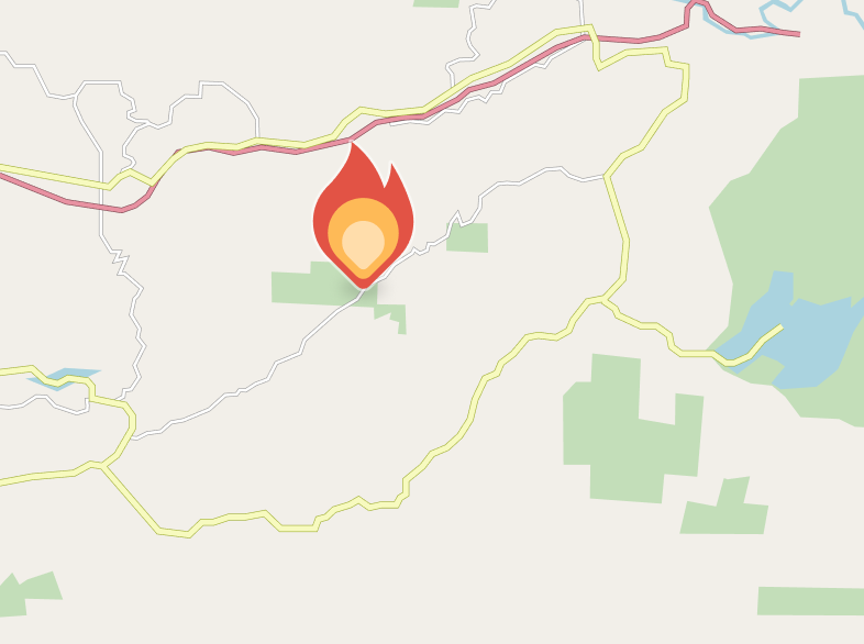
Liam Winstead, Staff Reporter
Jun 30 at 7:17 PM EDT
The fire is 688 acres and now 10% contained, per CAL FIRE RRU on X. All evacuation warnings and orders remain in place.
Watch DutyWatch Duty - Wildfire Maps & AlertsReal-time information about wildfire and firefighting efforts nearby
#WolfFire #RiversideCounty #CAwx
Brent Courtney, Staff Reporter
Jun 30 at 5:16 PM EDT
The fire has been mapped at 2413.6 acres by CAL FIRE Intel aircraft. Their perimeter is visible on the Watch Duty map under the Active Fire Perimeters map layer.
Note: Fire perimeters are preliminary and indicate general burn area but do not reflect structure protection efforts by firefighters. A structure within a fire perimeter may not be damaged or destroyed.
Brent Courtney, Staff Reporter
Jun 30 at 4:56 PM EDT
The fire is now 30% contained, remaining at approximately 1400 acres, per Incident Command.
protect.genasys.comGenasys ProtectGenasys Protect helps you stay safe in an emergency and keeps you safe wherever you go. The data in Genasys Protect comes straight from your local officials, and can tell you about danger nearby and how to stay safe.
#JuniperFire #RiversideCounty #CAwx
Liam Winstead, Staff Reporter
Jun 30 at 6:36 PM EDT
Evacuation Warnings have been issued for Zones RVC-1174 & RVC-1175.
Per Genasys. These zones can be viewed on the Watch Duty map & on the Genasys Protect Evacuation Map.
Jun 30 at 6:28 PM EDT
Evacuation Warnings have been issued for Zones RVC-1061 & RVC-1272.
Per Genasys. These zones can be viewed on the Watch Duty map & on the Genasys Protect Evacuation Map.
Jun 30 at 6:00 PM EDT
An Evacuation Order has been issued for Zones RVC-1173 & RVC-1273-A.
Per Genasys. These zones can be viewed on the Watch Duty map & on the Genasys Protect Evacuation Map.
Additionally, the fire has been mapped at 688.6 acres by CAL FIRE Intel aircraft. Their perimeter is visible on the Watch Duty map under the Active Fire Perimeters map layer.
Note: Fire perimeters are preliminary and indicate general burn area but do not reflect structure protection efforts by firefighters. A structure within a fire perimeter may not be damaged or destroyed.
protect.genasys.comGenasys ProtectGenasys Protect helps you stay safe in an emergency and keeps you safe wherever you go. The data in Genasys Protect comes straight from your local officials, and can tell you about danger nearby and how to stay safe.
#JuniperFire #RiversideCounty #CAwx
From KTLA News: New wildfire explodes in Riverside County, prompting evacuations

These Inland Empire restaurants closed in 2024 – Press Enterprise https://www.diningandcooking.com/2153724/these-inland-empire-restaurants-closed-in-2024-press-enterprise/ #CafeFood #california #corona #highland #Italia #Italian #ItalianCafeFood #italiano #italy #norco #RanchoCucamonga #Restaurants #RestaurantsFoodAndDrink #RiversideCounty #Riverside; #SanBernardino #SanBernardinoCounty #Temecula #ThingsToDo